
Mapping the Dead
For more than four millennia, the Chinese landscape has doubled as a map of the living and the dead. From the monumental burial mounds of the Xia Dynasty to the elaborate imperial tombs of the Ming emperors, each generation of Chinese rulers and commoners left their marks underground as much as above it. Yet until recently, no one had systematically charted these burial sites to see how geography and history conspired to shape where people chose to rest.
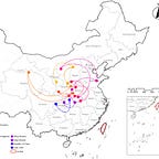
In a new study published in PLOS ONE,1 Quanbao Ma and colleagues from the Beijing University of Civil Engineering and Architecture have done just that. Using digital mapping and spatial analysis, the team plotted thousands of tomb sites across China and compared their distribution with changing social and environmental conditions over 4,000 years of recorded history.

Their findings reveal a pattern as dynamic as China itself. Tombs cluster not only where people once lived, but also where political stability, economic strength, and favorable geography made elaborate burial possible.
“Tombs are mirrors of their societies,” says Dr. Mei Zhang, an archaeologist at Fudan University who specializes in Chinese mortuary landscapes. “They reveal how the living negotiated their relationship with power, the environment, and the afterlife.”


