
Buto has been a ruin for over a thousand years. The site known today as Tell el-Fara’in, a cluster of three mounds rising from the agricultural plain of Egypt’s northwestern Nile Delta, carries occupation sequences stretching from the Predynastic period around 3800 BCE all the way to the early Islamic era in the seventh century CE. That is a very long history compressed into a relatively small footprint, and most of it is buried under meters of mud, debris, and later construction.
The uppermost mounds date mostly to the Ptolemaic and Roman periods. Walk the surface of Kom C, the southern settlement mound, and what you encounter is Roman-period material pushed up by the landscape. Beneath that is the Saite period. Below that, the Third Intermediate Period. Deeper still, the Old Kingdom, the Early Dynastic, and eventually the Predynastic. Each layer obscures the one below it, and the site sits in a floodplain where groundwater complicates any attempt to excavate the earliest levels.
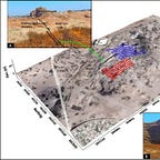
This is the challenge that a team from Kafrelsheikh University, Egypt’s National Authority for Remote Sensing and Space Sciences, and Durham University recently took on at Kom C. Their approach1 combined two tools: a radar satellite and electrical resistivity tomography. The goal was not to dig blindly but to know, before breaking ground, what was there and at what depth.


